Driving from Entebbe to Bwindi: How Long, Which Route and What to Expect
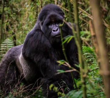
Driving from Entebbe to Bwindi is one of the most important overland safari journeys in Uganda because it connects the country’s main international gateway at Entebbe International Airport with the primate-rich montane rainforest of Bwindi Impenetrable National Park. This is not a simple point-to-point transfer. It is a full-day overland transition across Uganda’s central plateau, Rift Valley escarpments, agricultural belts, and forested highlands.
Unlike short safari transfers, this route is shaped by road conditions, seasonal weather, chosen sector in Bwindi, and stopover strategy. Understanding it properly is essential for gorilla trekking logistics because arrival timing directly influences rest, acclimatization, and trekking readiness the following morning.
Distance and Driving Time Reality
Average Duration Range
The drive from Entebbe to Bwindi typically takes between 8 and 10 hours under normal conditions. However, this can extend to 11+ hours depending on traffic leaving Kampala, road works, rainfall, and the specific Bwindi sector being accessed.
Bwindi is not a single-entry destination—it has multiple trekking sectors, and each one slightly changes the final driving time.
Why Time Varies So Much
The variation is caused by three main factors:
- Urban exit congestion around Kampala
- Road quality differences along western Uganda corridors
- Final access roads into Bwindi’s forest sectors
The last segment into Bwindi is often the slowest due to winding, mountainous terrain and unpaved forest approach roads.
Route Options from Entebbe to Bwindi
Route 1: Entebbe → Kampala → Masaka → Mbarara → Kabale → Bwindi
This is the most commonly used and standard safari route.
It passes through Uganda’s central highway system and continues through the southwestern corridor toward Bwindi. This route is generally preferred for:
- First-time gorilla trekking travelers
- Standard safari itineraries
- Most lodge transfer systems
The road is mostly paved until the final approaches to Bwindi.
Route 2: Entebbe → Kampala → Mubende → Fort Portal → Ishasha → Bwindi
This alternative route is longer in distance but often used when combining Queen Elizabeth National Park with Bwindi.
It passes through crater lake regions and western Uganda’s scenic highlands before entering southern Bwindi sectors.
This route is more scenic but less direct.
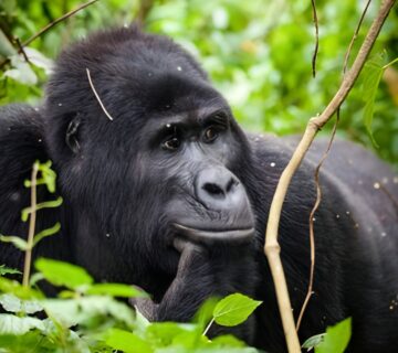
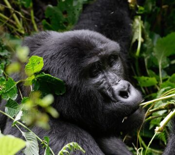
Bwindi Entry Sectors and How They Affect Driving Time
Bwindi Impenetrable National Park has multiple trekking sectors, and each one changes your final approach significantly.
Buhoma Sector (Northern Bwindi)
This is the most accessible sector from Kampala via Mbarara–Kabale route. Road conditions are relatively stable, and final access roads are shorter compared to southern sectors.
Typical drive time: 8–9 hours
Rushaga Sector (Southern Bwindi)
Rushaga requires additional driving beyond Kabale through winding mountain roads. It is slightly longer and more physically demanding on road conditions.
Typical drive time: 9–10+ hours
Nkuringo Sector (Southwestern Ridge)
Nkuringo is one of the most remote Bwindi sectors. It involves steep ridge access roads and more complex terrain navigation.
Typical drive time: 10–11+ hours
Ruhija Sector (Eastern Bwindi)
Ruhija sits at a higher elevation and is accessed via Kabale with forest ascent roads. It is moderately challenging but well connected.
Typical drive time: 8.5–10 hours
Road Conditions and Terrain Experience
Highway Sections from Entebbe to Western Uganda
The initial segment from Entebbe through Kampala and onward to Masaka and Mbarara is paved and generally smooth. This is the most stable portion of the journey.
It includes commercial towns, highway traffic, and standard road infrastructure.
Western Uganda Escarpment Driving
After Mbarara and Kabale, the road transitions into more undulating terrain. Elevation increases and the landscape becomes more mountainous and rural.
This is where driving becomes slower and more visually scenic.
Final Bwindi Approach Roads
The last 1–3 hours into Bwindi sectors involve narrow, winding roads. Some sections may be gravel or partially uneven depending on weather conditions.
These roads require careful driving and are often affected by rainfall, especially during wet seasons.
What You Actually See Along the Way
Urban-to-Rural Transition Corridor
The drive begins in a semi-urban environment around Entebbe and Kampala and gradually transitions into rural agricultural landscapes.
You will pass:
- Roadside markets
- Banana plantations
- Tea-growing regions
- Small trading centres
This gradual transition is one of the most distinct visual shifts in Uganda travel.
Rift Valley and Escarpment Views
As you move west, landscapes open into rolling hills and Rift Valley escarpments. This section offers some of the most scenic driving views in Uganda.
Highlands and Forest Edge Zones
Approaching Bwindi, vegetation becomes denser and more forested. Mist-covered hills and layered rainforest edges begin to dominate the landscape.
Stops and Break Points Along the Route
Masaka Town Stopover
Masaka is a common first major stop for refreshments and fuel. It marks the transition between central Uganda and the western corridor.
Mbarara City Stop
Mbarara is the main urban hub along the route and often serves as a lunch stop. It is the last major city before entering the more remote southwestern region.
Kabale Region Breakpoint
Kabale is the final major town before Bwindi. From here, the journey becomes more mountainous and forest-oriented.
Seasonal Influence on Driving Conditions
Rainy Season Travel (March–May, September–November)
During heavy rains, road sections in western Uganda can become slower due to reduced traction and occasional mud buildup on forest access roads.
Travel times may extend beyond 10–11 hours depending on conditions.
Dry Season Travel (June–August, December–February)
Dry seasons provide more stable road conditions and faster overall transit times. Visibility is also improved, making scenic sections more enjoyable.
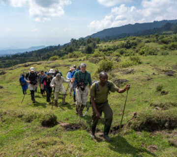
Vehicle Type and Comfort Considerations
Safari 4×4 Vehicles
Most gorilla trekking transfers use safari-equipped 4×4 vehicles designed for long-distance comfort and uneven terrain handling.
These vehicles are essential for the final Bwindi approach roads.
Private vs Shared Transfers
Private transfers offer flexibility in stop timing, pacing, and comfort level. Shared transfers are more budget-friendly but follow fixed schedules and routes.
Why This Drive Still Matters Despite Flight Options
Even though internal flights are available into Bwindi-adjacent airstrips, many travelers still choose road transfers because the journey itself is part of the safari experience.
It allows gradual ecological transition from Uganda’s urban core into its rainforest ecosystems, creating a continuous visual and cultural narrative before entering gorilla trekking zones.
Field Reality: What the Drive Feels Like in Practice
The Entebbe-to-Bwindi drive is not just a transfer—it is a full-day immersion into Uganda’s geographic diversity. The experience shifts from airport corridors to highway systems, then into agricultural heartlands, escarpment ridges, and finally deep forest approaches.
Fatigue is real due to duration, but so is the reward: by the time you arrive in Bwindi Impenetrable National Park, you have already traversed most of Uganda’s ecological zones in a single continuous movement.
The drive functions as a slow transition into gorilla trekking reality rather than a disconnected transport segment.
Start Planning Your Next Trip To Africa
If you can picture yourself in one—or several—of these exceptional retreats, the next move is simple. We design fully tailored African safaris that bring these experiences together seamlessly, from private gorilla encounters to luxury lodges in the heart of the wild.
Every detail is carefully planned, so your journey feels effortless from start to finish. Reach out in whichever way suits you best, and let’s begin crafting your safari.
Start Planning